
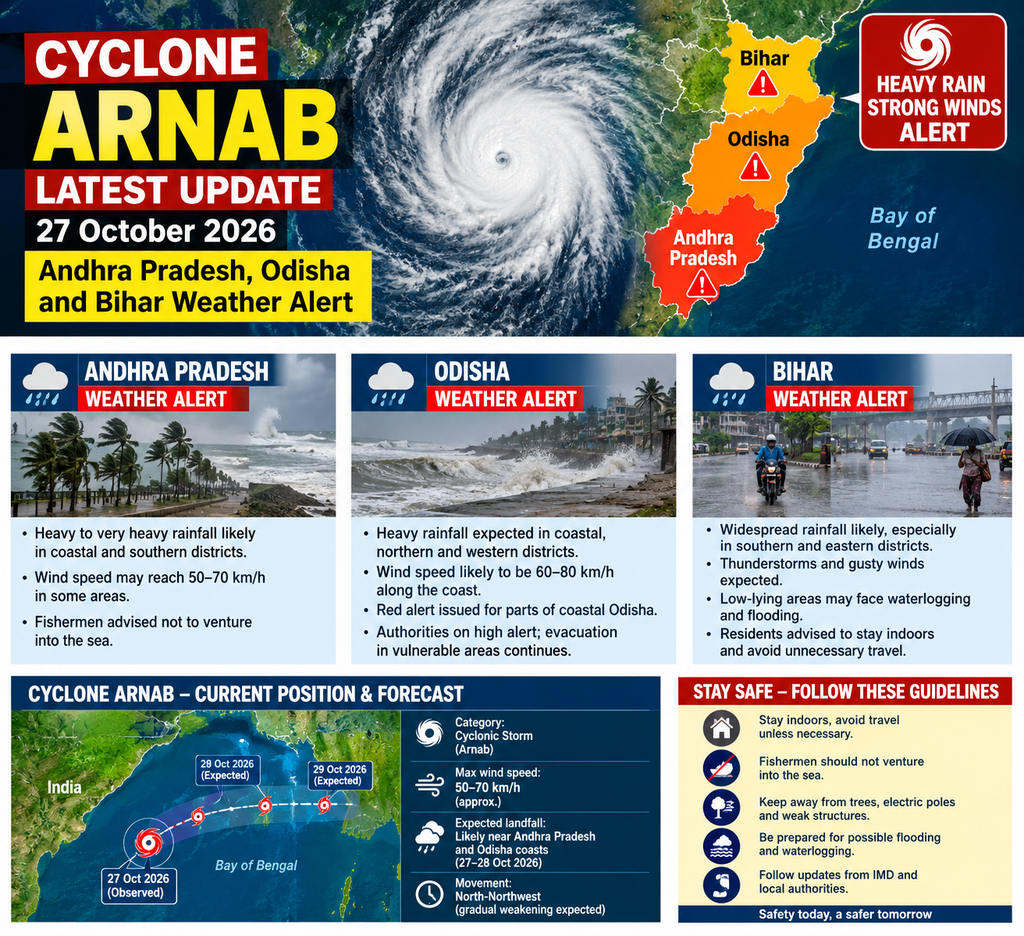
Very Severe Cyclonic Storm Arnab intensifies over the Bay of Bengal; landfall expected on the Andhra Pradesh-Yanam coast by forenoon on 28 October with winds of 115-125 kmph gusting to 140 kmph. Red alerts, evacuations, school closures and train cancellations in force as heavy rain threats extend inland to Odisha and later Bihar.
New Delhi / Visakhapatnam / Bhubaneswar / Patna, 27 October 2026: Cyclone Arnab, the first named tropical cyclone of the post-monsoon season over the Bay of Bengal in 2026, has rapidly intensified into a Very Severe Cyclonic Storm and is tracking toward the Andhra Pradesh and Yanam (Puducherry) coasts. The India Meteorological Department (IMD) has issued a red-level cyclone warning for coastal Andhra Pradesh and adjoining south Odisha, with landfall forecast by the forenoon of Wednesday, 28 October, between Bapatla and Visakhapatnam, close to Yanam. Sustained winds of 115-125 kmph, gusting to 140 kmph, are expected at landfall, accompanied by extremely heavy rainfall, storm surge of 1.0–1.5 m (locally higher near East Godavari and Yanam), and rough-to-phenomenal sea conditions.
As of early Tuesday (around 0000–0530 UTC / corresponding IST times on 27 October), Arnab lay centred near latitude 15.9°N and longitude 84.8°E over the west-central Bay of Bengal—approximately 260 km southeast of Visakhapatnam, 300 km east-southeast of Kakinada, 390 km east of Machilipatnam, 460 km east of Bapatla, and 380 km south of Gopalpur in Odisha. The system had moved nearly westwards or west-northwestwards at speeds of around 22 kmph in the preceding hours and is under continuous surveillance by the Doppler Weather Radar at Visakhapatnam. It is expected to continue west-northwestwards initially before recurving northwestwards toward the coast.
IMD intensity guidance indicates the storm has already reached Very Severe Cyclonic Storm status, with maximum sustained winds in the 130-140 kmph range (gusting higher) earlier in the period and potential for further strengthening to 150-160 kmph gusting to 180 kmph in the short term before some moderation near landfall. After landfall, rapid weakening is anticipated as the system interacts with land, dry air, and higher shear, transitioning to a Severe Cyclonic Storm, then Deep Depression, and eventually a well-marked low while tracking northward into interior regions.
Rainfall and Weather Impacts: Coastal Focus Shifting Inland
Extremely heavy rainfall (isolated places ≥21 cm) is very likely over coastal Andhra Pradesh and Yanam on 27 and 28 October, with heavy to very heavy falls more widely. Adjoining south Odisha faces similar threats of heavy rain and strong winds, particularly on 28 October. As the remnant system moves inland and northward, heavy to very heavy rainfall is forecast over parts of Chhattisgarh (28–29 October), eastern Telangana, Jharkhand, Bihar, and East Uttar Pradesh through 29–30 October or later. Squally winds, thunderstorms, and lightning are additional hazards.
Storm surge of 1.0–1.5 m above astronomical tide is expected to inundate low-lying coastal areas of Andhra Pradesh, with the highest peaks near Kakinada (East Godavari) and Yanam. Sea conditions will remain phenomenal until landfall, then gradually improve. Fishermen have been strictly advised to remain ashore; all those who had ventured out earlier reportedly returned safely in many areas. Beaches and tourist sites along the affected coasts have been restricted or closed.
Andhra Pradesh: Red Alert, Mass Preparations and Evacuations
Andhra Pradesh is in the primary impact zone. Districts including Eluru, NTR, Krishna, Konaseema, Kakinada, East and West Godavari, Guntur, Alluri Sitharama Raju, Anakapalli, and Visakhapatnam are under heightened alerts, with red alerts specifically flagged for 28 October in several coastal and adjoining areas. Chief Minister N. Chandrababu Naidu has directed round-the-clock vigilance, district control rooms, and timely warnings. The state released approximately ₹27 crore to 20 districts for relief and emergency response, with higher allocations (around ₹2 crore each) to the most vulnerable coastal districts such as Bapatla, Krishna, Konaseema, East and West Godavari, Kakinada, and Anakapalli.
Evacuations from low-lying and vulnerable coastal zones are underway. Authorities are prioritising the movement of thousands of residents, including arrangements for pregnant women (reports mention moving several thousand expectant mothers to safer health facilities). National Disaster Response Force (NDRF) teams—around 15 reported in key locations—along with State Disaster Response Force (SDRF), Army, Navy, Air Force, and Coast Guard units are positioned. Power utilities have stockpiled materials (tens of thousands of electric poles and related equipment) to restore supply quickly after potential outages. Educational institutions in affected districts have been closed, and the Andhra Pradesh Medical Council postponed certain counselling sessions.
South Coast Railway cancelled 53 train services on 27 and/or 28 October, affecting routes linked to Vijayawada, Rajahmundry, Machilipatnam, Narasapur, Bhimavaram, Kakinada Port, Guntur, and Visakhapatnam. Passengers have been urged to check the latest status. Ports have raised danger signals (Great Danger signals at key locations such as Kakinada, Visakhapatnam, and others).
Odisha: Southern Districts on Alert, Schools Closed, Teams Deployed
Although the core landfall is expected south of Odisha, southern districts face significant secondary impacts from heavy rain, strong winds (potentially gusting to 80 kmph or more in places), and possible flooding. Schools, colleges, and Anganwadi centres in six southern districts—Ganjam, Gajapati, Rayagada, Malkangiri, Koraput, and Nabarangpur—have been ordered closed on 28 and 29 October (with some earlier closures in Ganjam). Fishing and tourist activities have been banned in vulnerable areas.
Odisha has prepared cyclone shelters, released funds (reports of around ₹19 crore in some accounts for relief operations), and begun evacuations from high-risk zones. Dozens of ODRAF and NDRF teams are deployed. Special attention is being given to vulnerable groups, including shifting women in advanced stages of pregnancy (around 3,000 mentioned in some reports) to safer locations or hospitals. The state remains on high alert in coordination with central agencies.
Bihar and Inland Extension: Rain Alerts from 28 October Onward
Bihar, far from the landfall zone, is expected to experience the remnant effects as the system tracks northward after landfall. Heavy rainfall, thunderstorms, and strong winds are forecast, particularly from 28–30 October or into early November in some guidance. The Meteorological Department has issued yellow alerts for certain districts on 28 October and orange alerts for heavier activity around 29 October, with north Bihar potentially seeing more intense spells. Districts across the state, including those around Patna and further north, should prepare for disrupted weather, possible waterlogging, and impacts on agriculture.
Authorities in Bihar and eastern Uttar Pradesh have been specifically alerted by the National Crisis Management Committee and central agencies. Farmers have been advised to protect standing crops and equipment; residents should avoid open areas, trees, and electric poles during thunderstorms. While dry or relatively normal weather is expected in Bihar on 27 October itself (with mild mornings/evenings and daytime sunshine), the situation is set to change from the 28th. Similar inland rainfall is anticipated in parts of Jharkhand, Chhattisgarh, Telangana, and East UP.
Broader Context, Naming, and Preparedness Across the Region
Arnab was named by Bangladesh as part of the WMO/ESCAP regional naming list for the North Indian Ocean. It formed from a deep depression over the east-central and adjoining Bay of Bengal and underwent rapid intensification, aided by warm sea surface temperatures (around 29–30°C), favourable oceanic heat content, low-to-moderate wind shear in the environment, and supportive large-scale features including the Madden-Julian Oscillation.
The Centre has placed Andhra Pradesh, Odisha, Telangana, Chhattisgarh, and Puducherry on high alert, with additional vigilance for rainfall impacts in Bihar, Jharkhand, East UP, West Bengal (where southern districts may see heavy rain and gusty winds, though the core wind field is expected to spare Kolkata major damage), and other areas. Air India and other operators have issued advisories; travellers should monitor updates. Control rooms at state and district levels are operational, and public advisories emphasise staying indoors during peak impacts, securing loose objects, avoiding coastal areas and flooded roads, and following official channels (IMD, state disaster management authorities).
Satellite and radar imagery continue to show organised convection with eye features and intense thunderstorms. Models generally converge on a landfall near the specified Andhra-Yanam stretch, though exact timing and intensity at landfall carry some uncertainty within the forecast window (roughly late 27 to 28 October). Post-landfall, the system’s northward track will spread rainfall inland while the cyclone itself weakens quickly.
Authorities across the affected states stress that early action—evacuations, school closures, train cancellations, and prepositioning of response teams—aims to minimise loss of life and reduce damage. Residents in coastal Andhra Pradesh and south Odisha should treat the red alerts with utmost seriousness and complete any remaining preparations today. Those in Bihar and other inland areas should monitor forecasts closely over the coming days for heavy rain and related disruptions.
This is a developing situation. The latest official bulletins from the India Meteorological Department (mausam.imd.gov.in) and state disaster management authorities remain the primary sources for real-time updates, warnings, and local instructions. Stay safe and follow official guidance.
( NOTE: Report compiled from IMD bulletins, state government actions, and contemporaneous news coverage as of 27 October 2026 .)