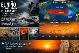


The El Niño event developing across the Pacific Ocean is likely to become the strongest in living memory, the UK Met Office has warned, with the potential to drive global temperatures to new extremes and heighten the risk of severe weather worldwide.
Professor Adam Scaife, head of long-range forecasting at the Met Office, described the emerging event in stark terms: “We should be clear that this is an unprecedented event. I have never seen an El Niño signal this intense in our forecasts.” Latest Met Office projections indicate sea-surface temperature anomalies in the key Niño regions could exceed 3°C above average as the phenomenon peaks later this year. Such levels would surpass anything recorded since systematic observations began around 1950 and rank among the most powerful events since the nineteenth century. Some independent analyses suggest anomalies could approach or even reach 4°C in places, raising the possibility that this could be the strongest El Niño in centuries.
El Niño is the warm phase of the El Niño-Southern Oscillation (ENSO), a natural climate cycle driven by interactions between the ocean and atmosphere in the tropical Pacific. Under normal conditions, trade winds blow from east to west, piling warm surface water in the western Pacific near Indonesia and Australia while allowing cooler, nutrient-rich water to upwell along the coasts of South America. During El Niño, those trade winds weaken or reverse. Warm water spreads eastward across the equatorial Pacific, suppressing upwelling and releasing vast amounts of heat into the atmosphere. This heat transfer typically raises global average surface temperatures by around 0.1–0.2°C or more, with effects lagging the peak ocean warming by several months.
The current event has been building for months. After a multi-year La Niña phase that helped keep global temperatures relatively moderated in some periods, the tropical Pacific began warming markedly in early 2026. By June, major agencies including the US National Oceanic and Atmospheric Administration (NOAA) declared El Niño conditions officially underway. Subsurface ocean data revealed an enormous reservoir of unusually warm water—more than 6°C above average in places—advancing eastward at depth. As this heat rises to the surface, sea-surface temperatures in the Niño 3.4 region (the central equatorial Pacific used as the primary index) have climbed rapidly. Weekly readings in mid-August already showed anomalies near or above +2.7°C in some datasets, with the event still intensifying.
Forecast models from the Met Office, NOAA, the European Centre for Medium-Range Weather Forecasts and other centres show strong agreement. The ensemble spreads are unusually narrow, increasing confidence that this will be a very strong or “super” El Niño. Peak strength is expected between October and January, with elevated temperatures and associated atmospheric patterns likely persisting into spring 2027. NOAA assessments in August gave greater than 90 per cent odds of a very strong event (Niño 3.4 anomalies of at least +2.0°C for several months) and a substantial chance that the three-month average will exceed previous post-1950 records.
Historical benchmarks underline the scale. The strongest modern events include 1982–83, 1997–98 and 2015–16, each producing peak Niño 3.4 anomalies in the +2.0 to +2.6°C range depending on the exact index and baseline used. The 1877–78 event, reconstructed from limited instrumental and proxy data, is often cited as one of the most extreme of the nineteenth century and was associated with widespread drought and famine. Some climate scientists, including Zeke Hausfather, have noted that if current forecasts materialise at the upper end, this 2026–27 episode could rank among the strongest of the past 500 or even 1,000 years, though certainty declines further back in time due to sparse records.
The combination of an exceptionally strong El Niño with the background of human-caused global warming is what most concerns scientists. Greenhouse-gas emissions have already raised the planet’s average temperature by more than 1.2°C above late-nineteenth-century levels. An El Niño of this magnitude will release additional heat stored in the ocean, almost certainly pushing 2027 to become the warmest year on record. Previous strong events contributed to temperature records in 1998 and 2016; the 2023–24 El Niño, though weaker than the current forecasts, helped produce consecutive record-hot years. With the climate system already primed, the temporary boost from this event is expected to be especially pronounced.
Regional weather impacts follow characteristic but not identical patterns from one El Niño to the next. In the tropics, the shift in atmospheric circulation typically brings drought risk to Indonesia, northern Australia, parts of Southeast Asia, southern Africa and northern South America. Reduced rainfall can stress water supplies, agriculture and ecosystems, elevating wildfire danger. Conversely, the southern United States, parts of South America (including southern Brazil, Uruguay and northern Argentina) and the Horn of Africa often experience heavier rainfall and flooding. The Indian monsoon can weaken, affecting summer rainfall across the subcontinent. In the Pacific, tropical cyclone activity tends to increase in the central and eastern basins while decreasing in the Atlantic, though warm Atlantic sea temperatures can sometimes offset that suppression.
For the United Kingdom and north-western Europe, strong El Niño events historically tilt the odds toward wetter and stormier conditions in autumn and early winter. The Met Office has highlighted an elevated risk of a wet, stormy season for the UK. Jet-stream patterns can become more active, increasing the frequency of Atlantic depressions tracking across the British Isles. While individual storms cannot be attributed solely to El Niño, the large-scale background makes such weather more probable. Milder winters are also possible in some scenarios, though the precise outcome depends on other factors including the North Atlantic Oscillation.
Beyond immediate weather, the economic and humanitarian stakes are high. Strong El Niños have historically been linked to multi-trillion-dollar global losses through crop failures, infrastructure damage, disrupted fisheries and health impacts. The 1997–98 event, for example, was associated with widespread drought, forest fires in Indonesia that produced hazardous haze, floods in East Africa and South America, and significant agricultural shortfalls. Coral reefs suffered extensive bleaching from elevated ocean temperatures. Similar pressures are anticipated this time, compounded by the higher baseline temperatures of the 2020s. Food security in drought-prone regions, marine ecosystems already stressed by warming and acidification, and communities vulnerable to flooding or heatwaves all face elevated risks.
Marine heatwaves are another near-certain consequence. As the Pacific warms, surrounding ocean basins often follow, stressing coral reefs, kelp forests and fisheries. The 2015–16 event produced one of the most severe global bleaching episodes on record. With ocean temperatures already elevated, the coming months could see further widespread coral mortality, with long-term consequences for biodiversity and coastal livelihoods.
Climate scientists emphasise that while El Niño is a natural phenomenon, its impacts are no longer purely natural. The atmosphere holds more moisture because of warming, intensifying rainfall extremes where they occur. Heatwaves become more severe on top of an already hotter baseline. Droughts can set in more rapidly as soils dry faster. Attribution studies of previous extremes have repeatedly shown that human-caused climate change amplifies the damage from ENSO-driven events.
Preparation is therefore critical. National meteorological services, the World Meteorological Organisation, and humanitarian agencies have been issuing early warnings for months. Farmers in at-risk regions are being advised to adjust planting calendars or crop choices where possible. Water managers are reviewing reservoir levels and contingency plans. Coastal communities in cyclone-prone areas are updating evacuation procedures. In the UK, local authorities and the Environment Agency are monitoring the seasonal outlook for potential flooding risks in the months ahead.
Forecast skill for ENSO has improved markedly over recent decades thanks to denser ocean observations (including Argo floats and satellite altimetry), better models and greater computational power. The tight clustering of current model projections is a positive sign for advance planning. Nevertheless, uncertainty remains around the precise peak magnitude and the detailed regional responses. Secondary climate patterns such as the Indian Ocean Dipole can modulate outcomes, and internal atmospheric variability will still produce surprises.
Looking further ahead, scientists continue to investigate whether climate change itself is altering the frequency or intensity of extreme El Niño events. Some modelling studies suggest a tendency toward stronger extremes in a warmer world, though the evidence is not yet conclusive. What is clear is that any given El Niño now occurs on a hotter, wetter and more energetic planet, magnifying its effects.
The Met Office’s latest assessment marks a significant escalation in the language used by official forecasters. Terms such as “unprecedented” and “strongest in living memory” are not deployed lightly. Combined with parallel warnings from NOAA, the WMO and other agencies, the message is consistent: a major climate disruption is unfolding and will influence weather patterns and global temperatures well into 2027.
As the Pacific continues to warm through the remainder of 2026, the world will watch closely. The coming months will test preparedness systems, agricultural resilience and the capacity of societies to manage compound extremes. While El Niño is temporary, the background warming that amplifies it is not. The event therefore serves as both an immediate hazard and a stark reminder of the longer-term challenge of climate change.
For the UK, the practical outlook includes a higher likelihood of unsettled autumn weather, with implications for travel, farming and flood risk management. Globally, the stakes are higher still: food production, water security, public health and ecosystems all stand to be affected. Early action based on the robust forecasts now available offers the best chance of reducing harm.
The developing El Niño is no longer a distant possibility. It is underway, intensifying, and set to leave a mark on the climate record and on the lives of millions.