
Kathmandu / Beijing — August 29, 2026
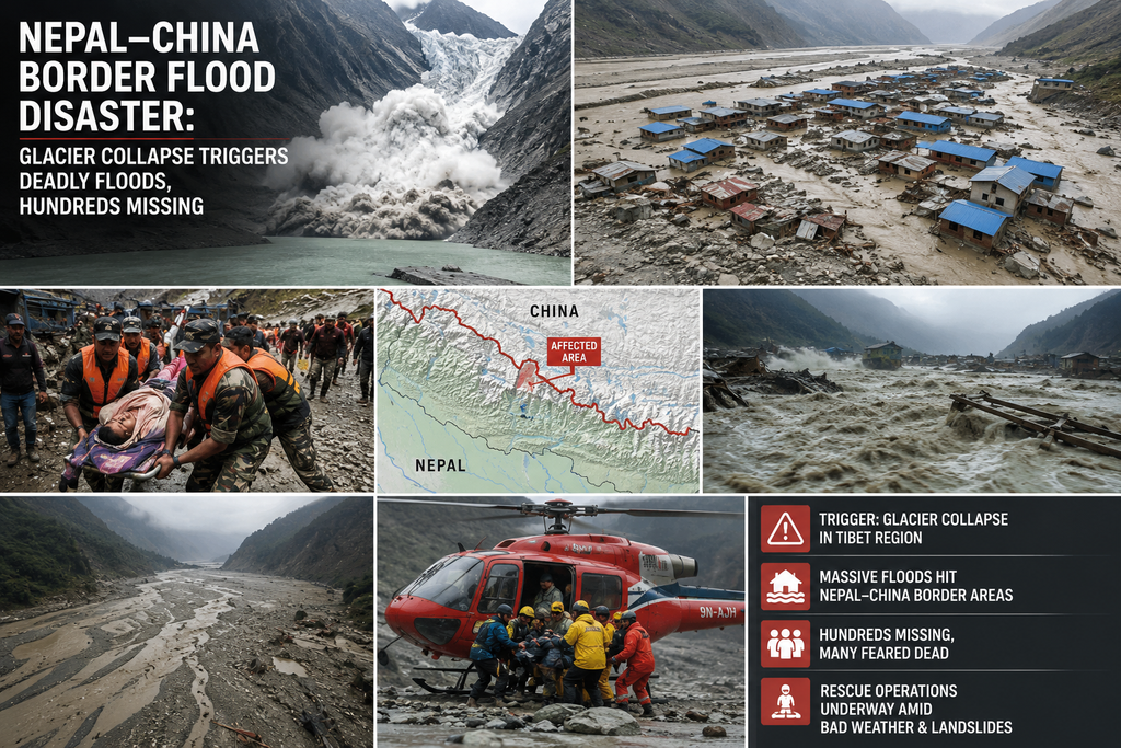
In the early hours of Wednesday, August 26, 2026, a catastrophic chain of events in the Himalayas unleashed one of the deadliest natural disasters in recent years along the Nepal-China border. A massive section of glacier and underlying bedrock on the north face of Langtang Lirung in northern Nepal collapsed, sending an ice-rock avalanche into the Lhende River (known as the Bhotekoshi in Nepal). The resulting torrent of ice, rock, mud, water, and debris surged downstream at high speed, devastating communities on both sides of the border, killing hundreds, and leaving more than a thousand people missing.
By late Friday, August 28, confirmed deaths stood at approximately 469 in Nepal and five in China’s Tibet Autonomous Region (specifically Gyirong County), according to official tallies from both governments and international reports. Nearly 1,000 people remained unaccounted for across the two countries, including hundreds of foreign nationals from more than 30 countries. Many of the missing were pilgrims, trekkers, and tourists travelling the popular route linking Kathmandu with Lhasa and the sacred Mount Kailash region. Rescue operations, already hampered by destroyed infrastructure, steep terrain, and ongoing secondary risks, faced further interruption as a newly formed barrier lake threatened additional flooding.
The Trigger: Glacier and Bedrock Collapse
Initial reports on August 26 pointed to a magnitude 4.4 earthquake near the border as the possible trigger. Seismic monitors detected the signal around 8:37 a.m. local time. However, the U.S. Geological Survey quickly revised its assessment. The landslide itself generated the seismic energy, which later registered as a magnitude 5.2 event caused by the glacial collapse and subsequent debris flow, not a tectonic earthquake.
Satellite imagery from Planet Labs, along with clearer views analysed by scientists including Dan Shugar of the University of Calgary and Kristen Cook of Université Grenoble Alpes, revealed the sequence. A substantial portion of the lower glacier, at roughly 5,200 meters (about 17,000 feet) elevation on Langtang Lirung, detached after the bedrock beneath it failed. The mass plunged approximately 1,200 meters (nearly 4,000 feet) onto the valley floor. The collapse involved not only ice but a large section of the mountainside itself.
The ice-rock avalanche entered the Lhende River roughly 20 kilometres northeast of the Nepal-China border crossing at Rasuwagadhi/Gyirong. Debris temporarily dammed the river, allowing water to accumulate before the natural barrier failed. The resulting flood wave, described by some witnesses and experts as resembling “liquid concrete” or a tsunami-like surge of mud, water, sediment, and boulders, raced through narrow gorges. Water levels in the Trishuli and related river systems rose by as much as 7 to 9 meters within 30 minutes in places. The flow travelled at speeds estimated at around 50 meters per second in sections, giving little warning or chance of escape.
Chinese government geologist Guo Zhaocheng noted that the debris flow extended more than 20 kilometres and incorporated glacial moraine as it moved, transforming into a powerful mudslide that struck port facilities and settlements on both sides of the border. Experts from Nepal’s National Disaster Risk Reduction and Management Authority and the International Centre for Integrated Mountain Development (ICIMOD) described it as a “glacier-inclusive flood” or ice-rock avalanche originating on the Nepali side.
Climate scientists quickly linked the event to broader trends in the Himalayas, often called the “Third Pole.” The region is warming faster than the global average, accelerating glacial melt, destabilising slopes, and increasing the frequency of such high-altitude failures. While glacial collapses and glacial lake outburst floods (GLOFs) have occurred before, the scale of this event—combining bedrock failure with massive ice detachment—stood out as particularly severe. Prashant Baral of ICIMOD described it as significantly larger than recent comparable incidents.
Devastation Across the Border
On the Nepali side, the flood tore through Rasuwa District and downstream areas including parts of Nuwakot, Syapru Besi, Trishuli, Betrawati, and Kolpurtar. Entire stretches of road, bridges, and hydropower infrastructure were obliterated. Villages were buried under meters of mud and debris. Videos circulating widely showed people fleeing as walls of water and sludge advanced, buildings collapsing, and vehicles being swept away. Before-and-after satellite images showed rivers widened dramatically, banks eroded, and landscapes transformed into brown-and-black wastelands of sediment.
In China, Gyirong County in Tibet suffered heavy damage, particularly around the Gyirong Port border crossing, a key trade and travel point. Mud lay more than five feet deep in places. Communications and roads were severed. Chinese Premier Li Qiang travelled to the site on August 27 to oversee operations, underscoring the high priority Beijing assigned to the response. President Xi Jinping sent a message of condolence to Nepali President Ram Chandra Paudel, emphasising the shared destiny of the two countries “connected by mountains and rivers” and offering assistance.
Casualty figures evolved rapidly and remained fluid due to the difficulty of accessing remote valleys. Early reports listed around 160–170 deaths; by Thursday and Friday, Nepali authorities reported hundreds dead, with Chinese figures lower but still significant. The missing included large numbers of foreigners: estimates ranged from several hundred to over 500 across both sides, among them substantial groups from India (many on pilgrimage), the United States, the United Kingdom, Ukraine, Australia, and other nations. Nepal’s tourism board reported hundreds of tourists from dozens of countries out of contact. On the Chinese side, more than 250 foreigners were among the missing at one point. Chinese authorities evacuated more than 555 tourists from Gyirong County.
Many of the missing were part of groups heading toward or returning from Mount Kailash, a site sacred to Hindus, Buddhists, Jains, and others. Tour operators and families awaited news with growing anxiety. One reported case involved an Indian tour leader guiding dozens of pilgrims; most of the group was unaccounted for after their vehicles were struck near the border.
Infrastructure losses compounded the human toll. Key bridges and sections of the highway linking Kathmandu to the border were destroyed or rendered impassable. Hydropower projects along the rivers sustained severe damage. Power, water, and communication networks in affected valleys were disrupted, isolating communities and complicating rescue logistics.
Secondary Threat: The Barrier Lake
Even as search-and-rescue efforts intensified, a new danger emerged. Debris from the original avalanche and mudslides created a barrier lake (also called an avalanche-induced or landslide-dammed lake) near the border, upstream from the Gyirong crossing. By Thursday, Chinese authorities estimated the lake held 1.5 to 2 million cubic meters of water. By Friday, the volume had risen above 2.5 million cubic meters. Forecasts indicated another 3 million cubic meters could flow in over the following days due to continued meltwater and expected rain, with peak risk around September 1. The volume was compared to roughly 1,200 Olympic-sized swimming pools.
Chinese authorities warned of high breach risk and potential secondary disasters including further collapses or avalanches. On Friday, they temporarily suspended or repositioned rescue teams, withdrawing personnel and vehicles to safer areas while monitoring the lake. An engineering team assessed conditions. By Friday afternoon, Chinese state media reported that risks had become manageable enough to allow operations to resume and intensify. Nepal’s disaster management authority similarly flagged rising water levels behind debris dams on its side of the Bhotekoshi system.
Rain forecasts for the coming week added urgency. Continued precipitation could accelerate inflows into the lake, raise river levels, and increase landslide risks on already saturated slopes. Both governments coordinated warnings and monitoring.
Rescue and Relief Operations
Rescue work unfolded under extremely difficult conditions. Steep valleys, cold high-altitude weather, destroyed access routes, and the risk of further flooding limited ground teams. Helicopters and military units from both countries conducted aerial searches and evacuations where possible. On the Chinese side, Premier Li Qiang’s presence signalled high-level coordination. China offered emergency aid to Nepal and pledged full support in searching for missing Chinese and foreign nationals.
In Nepal, the National Disaster Risk Reduction and Management Authority coordinated with the army, police, and local responders. Survivors described scenes of chaos and rapid inundation. Many who escaped did so by climbing to higher ground or being fortunate enough to be outside the main flow path. Bodies and debris continued to surface downstream as waters receded in some areas.
International response included expressions of concern and offers of assistance from various governments whose citizens were among the missing or affected. Families of the missing, particularly from India and other countries with large pilgrim and trekker contingents, pressed for information and support. Coordination challenges across the border were noted by some Nepali voices, who called for improved real-time information sharing on upstream hazards. Officials indicated that mechanisms for faster data exchange were being strengthened in the aftermath.
Broader Context and Climate Implications
The disaster has intensified scrutiny of climate-driven risks in the Hindu Kush Himalaya. Glaciers across the region are retreating rapidly. Permafrost thaw and changing precipitation patterns further destabilise high slopes. Millions of people live downstream of these mountains and depend on the rivers for water, agriculture, and hydropower, yet face growing exposure to sudden outburst events.
Experts emphasise that while individual collapses cannot always be predicted with precision, monitoring of glaciers, glacial lakes, and slope stability can improve early warning. Satellite surveillance, seismic networks, and ground-based sensors play critical roles. The event has also highlighted the vulnerability of critical infrastructure—roads, bridges, border facilities, and energy projects—built in hazard-prone valleys.
Questions remain about exact volumes of ice and rock involved, the precise sequence of damming and breaching, and whether similar unstable slopes exist nearby. Scientific teams continue analysing satellite data, seismic records, and field observations as access improves. Long-term recovery will require not only a search for the missing and support for survivors and families, but also reconstruction of destroyed infrastructure, assessment of secondary hazards, and strengthened cross-border disaster cooperation.
As of August 29, rescue and recovery operations continue amid the lingering threat from the barrier lake and forecast weather. Confirmed death tolls are expected to rise as more remote areas are reached and the missing are accounted for. Authorities on both sides of the border urge caution in affected river valleys and emphasise ongoing monitoring.
The tragedy underscores a stark reality of the warming Himalayas: the ice that has long defined these majestic peaks is becoming an increasingly unpredictable and deadly force for the communities living in their shadow. Coordinated scientific monitoring, resilient infrastructure planning, and rapid information sharing between neighbours will be essential to reducing the human cost of future events. For now, the focus remains on locating the hundreds still missing and preventing further loss of life from secondary flooding.