
Guwahati / Upper Assam | Late August 2026
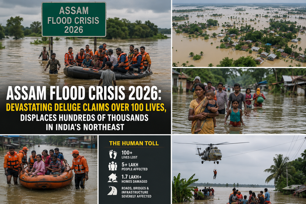
In one of the most severe flood disasters to strike India’s northeast in recent decades, relentless monsoon rains in mid-July 2026 unleashed catastrophic flooding across Assam, killing more than 100 people, inundating thousands of villages, and disrupting the lives of over a million residents. The crisis, centred primarily in Upper Assam districts, transformed fertile paddy fields into vast sheets of water, breached ageing embankments, and left communities scrambling for survival on rooftops, embankments, and makeshift camps. As floodwaters have largely receded by the end of August, the focus has shifted from emergency rescue to the long, arduous process of assessment, rehabilitation, and confronting the deeper structural and environmental factors that turned extreme rainfall into a human tragedy.
The floods began with exceptional rainfall between July 18 and 20, 2026. Upstream catchments in the Naga Hills of Nagaland and parts of Arunachal Pradesh recorded rainfall far exceeding normal levels—departures of 400–490 per cent in places such as Mokokchung and surrounding stations. The India Meteorological Department confirmed sustained heavy rain rather than a classic cloudburst, yet the volume was enough to overwhelm south-bank tributaries of the Brahmaputra: the Dikhow, Disang, Jhanji, and Dhansiri. These rivers rose rapidly, breached embankments, and flooded low-lying areas of Sivasagar, Charaideo, Jorhat, and Golaghat before the main Brahmaputra itself had peaked—an inversion of the more gradual mainstem flooding that characterises many Assam disasters.
At the height of the crisis in late July, official figures from the Assam State Disaster Management Authority (ASDMA) and related reports indicated that more than 1.14 million people were affected across multiple districts, with peak single-day estimates around 2.12 lakh in eight districts and cumulative impacts reaching higher. Over 2,600 to 2,700 villages were reported flooded at various stages. Crop areas exceeding 20,000–34,000 hectares were submerged at different points, livestock losses ran into the tens of thousands (with more than 11,000 animals reported killed in some assessments), and critical infrastructure—roads, bridges, power lines, schools, and houses—suffered extensive damage. Relief camps sheltered tens of thousands at the peak, with numbers fluctuating as waters rose and fell.
The human cost mounted steadily. Early reports recorded the first fatalities in late June and early July during the initial wave, but the main surge in deaths came after the mid-July deluge. By late July the toll stood in the 60s and 70s; by early August it had climbed past 80 and then 98; later updates put the figure above 100, with some reports citing 101, 103, or 105 by mid-to-late August. Sivasagar emerged as one of the hardest-hit districts in terms of fatalities, alongside Charaideo and Jorhat. Many deaths occurred when walls of water swept through villages with little warning, carrying away people, livestock, and homes. Survivors described the onset as sudden and overwhelming—“like a tsunami” or “sea waves”—leaving families separated and searching for missing relatives days and weeks later.
Scale of Devastation and District Impacts
Upper Assam bore the brunt. Charaideo, Sivasagar, Jorhat, and Golaghat recorded the highest numbers of people affected and the most severe inundation. In late July, Charaideo alone saw figures approaching or exceeding 1.3–1.4 lakh people impacted at certain points, with Sivasagar and Jorhat also in the tens of thousands. Embankment breaches on rivers such as the Bhogdoi near Jorhat and later erosion concerns on the Disang compounded the crisis, cutting ferry links to Majuli and isolating communities. Agricultural land—particularly winter paddy fields—was left under layers of silt, rendering large stretches unusable for the season and threatening food security and rural livelihoods.
Beyond the immediate human and agricultural toll, the floods damaged power infrastructure, disrupted transport, and raised public-health risks from stagnant water, overcrowded camps, and compromised sanitation. Wildlife in and around protected areas such as Kaziranga National Park and the Hoollongapar Gibbon Sanctuary faced threats, though comprehensive official wildlife casualty figures were slower to emerge. The economic cost of rehabilitation has been projected in the hundreds of crores of rupees, with preliminary assessments pointing to needs exceeding ₹1,000 crore for recovery in the worst-hit areas.
Root Causes: Climate Extremes Meet Chronic Vulnerabilities
Assam is among India’s most flood-prone states. Roughly 40 per cent of its land is vulnerable to inundation from the Brahmaputra, the Barak, and their numerous tributaries. The Brahmaputra, one of Asia’s largest rivers by discharge, carries enormous sediment loads from the Himalayas. When the river’s gradient flattens in the Assam plains, sediment settles, raising riverbeds and reducing channel capacity. Annual monsoons routinely bring high water; the state has long lived with seasonal flooding. Yet the 2026 event stood out for its rapid onset and upstream-driven character.
Experts and researchers emphasise that extreme rainfall was the trigger, not the sole cause. Decades of deforestation and land-use change in the upstream hills of Nagaland and Arunachal have reduced the landscape’s ability to absorb and slow runoff. Mining, quarrying, jhum (shifting) cultivation, and hill-cutting for infrastructure have destabilised slopes, increasing sediment delivery into rivers. In the plains, wetland loss, encroachment on floodplains, riverbed mining, and an ageing network of embankments—many constructed decades ago and inadequately maintained or raised—have amplified vulnerability. When heavy rain fell on already saturated catchments, water and silt surged downstream faster than the constrained river systems and embankments could handle.
Climate change is widely cited as a contributing factor to the intensity and unpredictability of rainfall patterns. Officials, including Assam ministers, pointed to erratic monsoon behaviour. Independent analyses, however, stress that the disaster was “human-made” in significant measure: the interaction of extreme weather with sediment aggradation, embankment fragility, and socio-institutional gaps in preparedness and land management. The event has renewed calls for a shift from purely structural flood control (more embankments) toward integrated approaches that include wetland restoration, better sediment management, scientific mapping of risk, improved early-warning systems, and cross-border basin coordination, given that rainfall and land-use changes upstream affect Assam regardless of administrative boundaries.
Government and Institutional Response
The Assam government, led by Chief Minister Himanta Biswa Sarma, mobilised the State Disaster Response Force (SDRF), National Disaster Response Force (NDRF), Army units, police, fire services, and civil administration for rescue and relief. Hundreds of relief camps and distribution centres were established, providing shelter, food, and essentials to tens of thousands. Power restoration efforts proceeded in phases after precautionary shutdowns. The Centre released a substantial advance from the State Disaster Response Fund—reports cite around ₹379 crore as part of broader allocations to flood-affected states.
As waters receded, the emphasis moved to assessment and rehabilitation. From early August, door-to-door surveys were ordered in the four worst-hit districts (Jorhat, Sivasagar, Golaghat, and Charaideo) running through the end of the month, with verification and fund estimates targeted for early September. Interim cash assistance via direct benefit transfer reached tens of thousands of families, with total interim relief figures climbing into the hundreds of crores. A six-month loan repayment moratorium was announced for affected borrowers in the worst districts. The government also signalled longer-term measures, including plans for extensive concrete embankment construction and continued investment in flood management, supported by World Bank and Asian Development Bank projects. Central ministers visited, and assurances of full support for reconstruction were conveyed.
International and domestic humanitarian actors, including Red Cross/Red Crescent mechanisms, launched targeted operations to assist tens of thousands with shelter, household items, health, water, and sanitation support over multi-month timeframes. Local civil society, diaspora groups, and individuals also contributed aid and fundraising, though authorities later indicated they would verify certain private collections to ensure proper utilisation.
Human Stories Amid the Crisis
Behind the statistics lie individual tragedies and acts of resilience. In Sivasagar villages, families recounted watching walls of water sweep through homes in minutes, separating parents from children. Search efforts continued for some missing persons even after the waters receded. Farmers surveyed silt-covered fields that once promised a harvest. Livestock owners mourned animals swept away or left without fodder. In relief camps, communities shared space, food, and stories while waiting for waters to drop and for officials to assess damage to homes. Rescue teams navigated breached embankments and shallow, debris-filled waters; later phases involved more complex rehabilitation logistics as people sought to return to damaged houses and restore livelihoods.
Broader Context and Outlook
Assam’s flood history is long and costly. Decades of embankment construction—thousands of kilometres along the Brahmaputra and tributaries—have provided partial protection but also created a false sense of security in some areas and concentrated risk when breaches occur. Sediment dynamics, climate variability, and upstream land-use pressures mean that purely defensive infrastructure is insufficient. Analysts argue for multi-layered strategies: strengthened and better-maintained structures where necessary, restoration of natural buffers (wetlands, forests), improved forecasting and community-based early warning, regulated mining and land use in catchments, and economic support that helps households recover without deepening debt or dependence.
By late August 2026, the acute emergency phase had largely passed. Residual flooding affected far fewer people—tens of thousands rather than hundreds of thousands—and the death toll had stabilised in the low hundreds. Damage assessment and the first tranches of rehabilitation support were underway. Yet the scars on the landscape, the economy, and communities will take years to heal. For many in Upper Assam, the 2026 floods are not an isolated catastrophe but another chapter in a recurring story that grows more intense with changing climate and cumulative environmental stress.
The crisis has once again placed Assam’s vulnerability on the national and international radar, underscoring the need for sustained investment in resilience rather than repeated cycles of disaster, relief, and temporary recovery. As the monsoon season continues and recovery efforts intensify, the people of Assam—supported by state and central agencies, civil society, and their own determination—face the dual challenge of rebuilding lives while pressing for the systemic changes that might lessen the fury of the next deluge.