

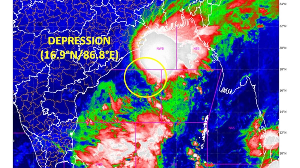
Bhubaneswar/Visakhapatnam, September 23, 2026 – A deep depression over the west-central and adjoining northwest Bay of Bengal is bearing down on the north Andhra Pradesh–south Odisha coastline, with the India Meteorological Department (IMD) forecasting landfall as a deep depression between Visakhapatnam and Gopalpur by the night of September 23. The system, which intensified from a depression earlier on Tuesday, September 22, is expected to bring widespread heavy to very heavy rainfall, isolated extremely heavy downpours, and squally winds of 55-65 kmph gusting to 75 kmph along and off the affected coasts. Authorities in both states have placed multiple districts on high alert, closed schools in vulnerable areas, readied shelters and disaster response teams, and issued strict advisories to fishermen and residents in low-lying regions.
As of 1730 hrs IST on September 22, the deep depression was centred near latitude 18.0°N and longitude 85.4°E, approximately 140 km east-southeast of Kalingapatnam in Andhra Pradesh, 150 km south-southeast of Gopalpur in Odisha, 210 km south-southwest of Puri in Odisha, and 220 km east of Visakhapatnam in Andhra Pradesh. It had moved west-northwestwards at about 7 kmph during the preceding six hours after earlier tracking westwards at higher speeds. The IMD has stated that the system will continue its west-northwestward path and cross the coast as a deep depression by the night of September 23. Officials have clarified that while speculation about intensification into a named cyclonic storm (potentially “Arnab”) has circulated, current forecasts indicate it will remain a deep depression rather than escalate further into a cyclonic storm.
This weather system arrives as the southwest monsoon continues its gradual withdrawal from northwest India. A trough associated with the depression extends across coastal Andhra Pradesh and Karnataka, contributing to the broader rainfall pattern across eastern and central India. The system is expected to produce disproportionately heavy rain over a wide swathe of eastern India in the coming days as it interacts with the retreating monsoon circulation.
Detailed Track and Intensity Evolution
The system originated as a well-marked low-pressure area over the Bay of Bengal and adjoining regions earlier in the week. It intensified into a depression by September 21-22 and further into a deep depression by the evening of September 22. Earlier positions placed it farther east, around 180-220 km southeast of Gopalpur and 270-320 km east of Visakhapatnam, with movement speeds ranging from 17-18 kmph westwards before slowing as it organised. Maximum sustained winds associated with the deep depression are in the range supporting squally conditions, with forecasts indicating further organisation as it approaches the coast.
Sea conditions over the west-central and adjoining northwest Bay of Bengal have deteriorated to rough to very rough, occasionally high, with widespread rain or thundershowers and isolated heavy to very heavy rain. Visibility is moderate, becoming poor to very poor in heavy rain. Similar rough conditions prevail along and off the north Andhra Pradesh–Odisha–West Bengal coasts and are expected to persist through September 24. Fishermen warnings remain in force across these areas until at least September 24-25, with some advisories extending guidance through September 25 or early September 26.
Port authorities have kept Local Cautionary Signal No. 3 hoisted at several locations, including Kalingapatnam, Bheemunipatnam, Visakhapatnam, Gangavaram, and Kakinada in Andhra Pradesh, as well as relevant ports in Odisha and West Bengal.
Rainfall Forecast for Odisha
Odisha is expected to bear the initial and most intense impact, particularly in southern and coastal districts. The IMD has issued red alerts (take action) for several districts. Heavy to very heavy rainfall with isolated extremely heavy rain is forecast for Koraput, Gajapati, and Ganjam on September 23-24. Red alerts also cover Kalahandi, Nabarangpur, Koraput, and Malkangiri for September 24-25. Orange and yellow alerts apply more broadly across coastal and southern Odisha, including areas such as Puri, Khurda, Nayagarh, Jagatsinghpur, Cuttack, and others.
Rainfall is likely to continue widely through September 25, with very heavy rain at isolated places possible on that day, followed by heavy rain on September 26 in some forecasts. Districts facing elevated flash-flood risk include Gajapati, Ganjam, Nayagarh, Puri, and Khurda. The heaviest rain band is projected over a zone linking areas such as Kalimela, Kirandul, Srikakulam, Jagdalpur, and Umerkote, straddling southern Odisha, north Andhra Pradesh, and adjoining Chhattisgarh.
Already on September 22, heavy rain had begun lashing parts of coastal and southern Odisha, prompting early school closures and heightened vigilance. The system is expected to linger somewhat over southern coastal districts after landfall, prolonging the rainfall spell before the remnant moves further inland toward Chhattisgarh and beyond.
Rainfall Forecast for Andhra Pradesh
Coastal Andhra Pradesh, particularly the northern districts, faces a similar threat of heavy to extremely heavy rainfall. Extremely heavy rain is possible at isolated places in Srikakulam, Vizianagaram, and Parvathipuram Manyam. Heavy to very heavy rain is forecast for Alluri Sitharama Raju, Anakapalli, Visakhapatnam, and adjoining areas on September 23-24, with heavy rain continuing at isolated places into September 25. Widespread rain is expected across coastal Andhra Pradesh and Yanam.
Schools in Visakhapatnam, Anakapalli, Srikakulam, and Alluri Sitharama Raju districts were declared closed on September 23 as a precautionary measure. Red and orange alerts have been issued for northern coastal districts. Flash-flood risk is noted as low to moderate in Vizianagaram and Srikakulam. Strong surface winds of 50-60 kmph are possible along the coast, rising in association with the approaching system.
The rainfall is expected to help address some of the cumulative monsoon deficit in parts of the state, which had been significant earlier in the season, though the intensity raises concerns about waterlogging and localised flooding in already saturated areas.
Broader Regional Impact
Beyond Odisha and Andhra Pradesh, the system will influence rainfall across a large part of eastern and central India. Heavy to very heavy rainfall with isolated extremely heavy amounts is forecast over Chhattisgarh and Telangana on September 23-24 and into subsequent days. Jharkhand, Bihar, Gangetic West Bengal, and parts of Vidarbha and Madhya Pradesh are also likely to see significant rain as the system or its remnant progresses. The IMD has highlighted potential impacts extending into the week, with widespread rain possible over eastern India through September 25-27 in some projections.
Squally Winds, Sea Conditions, and Marine Safety
Squally winds of 55-65 kmph gusting to 75 kmph are expected along and off the south Odisha–north Andhra Pradesh coasts from the morning of September 23 through the evening of September 24. Over the Bay itself, similar or slightly stronger squally conditions prevail. Sea conditions will remain rough to very rough, occasionally high, with poor visibility in rain. Fishermen have been repeatedly advised not to venture into the sea along and off the Odisha, Andhra Pradesh, and West Bengal coasts, as well as the central and northwest Bay of Bengal, until September 24 or 25 (with some warnings extending further). Those already at sea have been urged to return to the coast immediately.
Ferry services across Chilika Lake in Odisha have been halted as a precaution. Rough seas also pose risks to coastal shipping and port operations.
Government Preparedness and Response Measures
Both state governments have activated high levels of preparedness. In Odisha, Chief Secretary Anu Garg chaired review meetings and placed collectors of at least 11 districts on high alert. Focus areas include waterlogging, urban flooding, landslides, and mudslides in vulnerable terrain. Cyclone and flood shelters have been kept ready, with essential supplies (drinking water, food, medicines, power backup) stocked. The Odisha Disaster Rapid Action Force (ODRAF) has deployed 33 teams, with 24 positioned in vulnerable districts (including multiple units in Ganjam, Koraput, Gajapati, Malkangiri, and Rayagada) and others held in reserve. Leave for government employees in affected areas has been cancelled in some cases. Reservoir levels, particularly Indravati (around 84% capacity), Telengiri, Balimela, and Kolab, are under close monitoring, with releases managed where necessary to create storage buffers. Ghat roads prone to landslides, such as Kalinga Ghati, have faced restrictions.
District administrations in Ganjam and elsewhere have inspected shelters and interacted directly with fishing communities. Public address systems have been used in coastal districts including Puri, Khurda, Jagatsinghpur, Balasore, Bhadrak, and Kendrapara to disseminate warnings.
In Andhra Pradesh, the State Disaster Management Authority and district administrations have issued similar alerts. School and anganwadi closures in northern districts reflect the seriousness of the expected rainfall. Local administrations are monitoring low-lying areas for possible inundation and preparing for traffic disruptions.
The IMD has shared updates with the Chief Secretaries of Odisha, Andhra Pradesh, West Bengal, Jharkhand, Chhattisgarh, Madhya Pradesh, Maharashtra, and Puducherry to ensure coordinated awareness.
Rain Alerts Summary and Expected Impacts
- Red Alert (Take Action): Southern Odisha districts (Koraput, Gajapati, Ganjam on 23-24; Kalahandi, Nabarangpur, Koraput, Malkangiri on 24-25); northern coastal Andhra Pradesh districts for extremely heavy rain spells.
- Orange Alert (Be Prepared): Broader coastal and adjoining inland areas in both states, with heavy to very heavy rain likely.
- Yellow Alert (Be Aware): Additional districts for heavy rain and thunderstorms.
Expected impacts include waterlogging and localised flooding in low-lying and urban areas, disruption of road traffic, potential landslides in hilly southern Odisha and northern Andhra terrain, rising river levels, and possible damage to standing crops (particularly paddy) and infrastructure such as power lines or weak structures from gusty winds. Agricultural operations may face challenges, and farmers have been advised to take protective measures for crops and livestock where feasible.
Comprehensive Safety Advisory
Residents in coastal and southern districts of Odisha and northern coastal Andhra Pradesh should remain highly vigilant. Key recommendations from authorities and the IMD include:
- Avoid unnecessary travel, especially on roads prone to waterlogging or in hilly areas susceptible to landslides. Do not attempt to cross flooded roads or swollen streams.
- Those in low-lying or flood-prone areas should be prepared to move to higher ground or designated shelters if advised by local officials. Keep emergency kits ready with essentials, documents, medicines, and torches.
- Fishermen must not venture into the sea. Monitor official updates closely.
- Stay indoors during peak rainfall and strong wind periods. Secure loose outdoor objects that could become projectiles in gusty winds.
- Follow instructions from district administrations, police, and disaster management teams. Listen to official bulletins rather than unverified social media claims.
- Schools and anganwadis in affected districts are closed; parents should ensure children remain safely at home.
- Monitor river and reservoir levels if living downstream. Report any emergencies to local control rooms or helplines established by the administrations.
- Power and communication disruptions are possible; keep mobile phones charged and have alternative light sources.
The IMD continues to issue frequent updates through its regional centres in Bhubaneswar, Visakhapatnam/Amaravati, and national channels. Residents are urged to follow these official sources for the latest track, intensity, and warning changes, as tropical systems can evolve.
While the deep depression is not forecast to become a full cyclone at this stage, its rainfall potential remains significant given the already wet ground conditions in parts of the region and the slow-moving nature near the coast. Authorities emphasise that preparedness measures are focused on zero loss of life and minimising disruption. The system’s remnant is likely to continue producing rain as it moves inland after landfall, affecting central India in subsequent days.
As the night of September 23 approaches, focus remains on the precise landfall point between Visakhapatnam and Gopalpur, the peak rainfall intensity over southern Odisha and north coastal Andhra Pradesh, and the effectiveness of on-ground response mechanisms already activated across both states. Continuous monitoring and adherence to safety advisories will be critical through the peak impact period of September 23-25.