
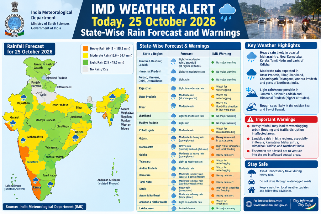
New Delhi, 25 October 2026: The India Meteorological Department (IMD) has issued significant weather warnings for Sunday, 25 October 2026, as a depression over the east-central and adjoining southeast Bay of Bengal intensifies. The system is expected to deepen into a deep depression today and further strengthen into a cyclonic storm by the morning of 26 October, with potential progression toward a severe cyclonic storm later. This development, combined with the ongoing northeast monsoon activity over southern peninsular India, is driving heavy to extremely heavy rainfall, thunderstorms, lightning, and gusty winds across multiple states, particularly in the south and parts of the east.
The forecast remains valid from approximately 0830 hours IST on 25 October until 0830 hours IST on 26 October for the primary daily warnings, with multi-day outlooks extending through 29–30 October for evolving impacts from the Bay system. Officials urge continuous monitoring of updates via the IMD website and regional centres, as the system’s track toward the Andhra Pradesh–Odisha coast will shape rainfall intensity in the coming days.
Synoptic Situation and Overall Outlook
As of the morning of 25 October, the depression lay centred near 15.5°N and 91.0°E, roughly 470 km north-northwest of Sri Vijaya Puram (Andaman Islands) and several hundred kilometres east-southeast of key Andhra Pradesh coastal stations. It is forecast to move nearly southwards initially, intensify into a deep depression, then recurve west-northwestwards over the east-central and adjoining southeast Bay of Bengal. By the morning of 26 October, it is likely to become a cyclonic storm over the east-central and adjoining west-central Bay, with further intensification possible.
This setup is supporting widespread rainfall over southern peninsular India under the northeast monsoon, which has already set in over Tamil Nadu, Puducherry, Karaikal, coastal Andhra Pradesh, Rayalaseema, south interior Karnataka, Kerala and Mahe. Fairly widespread to widespread rain is expected over Lakshadweep and Tamil Nadu–Puducherry–Karaikal on 25–26 October, and over Kerala and Mahe through 25–28 October. Isolated heavy to extremely heavy spells are the primary concern.
States and Districts Most Affected: Detailed Rainfall and Warning Categories
Kerala and Mahe face the highest alerts. IMD has issued a red alert (extremely heavy rainfall exceeding 204.5 mm in 24 hours) for districts including Malappuram, Kozhikode and Wayanad on 25 October, with Idukki and Palakkad under red alert on 26 October. Orange alerts (very heavy rainfall of 115.6–204.4 mm) cover additional districts such as Thrissur, Palakkad, Kannur and Kasaragod in the broader window, while yellow alerts (heavy rainfall of 64.5–115.5 mm) apply to Thiruvananthapuram, Kollam, Pathanamthitta, Alappuzha, Kottayam, Ernakulam and others. Heavy to very heavy rainfall with isolated extremely heavy downpours is very likely at isolated places over Kerala and Mahe on 25–26 October. Thunderstorms with lightning and gusty winds of 30–40 kmph are also expected.
Tamil Nadu, Puducherry and Karaikal are under similar high-impact warnings. Heavy to very heavy rainfall with isolated extremely heavy spells is forecast at isolated places on 25–26 October. Districts highlighted for heavy to very heavy rain include the Nilgiris, Villupuram, Cuddalore, Mayiladuthurai, Nagapattinam, Tiruvarur, Thanjavur, Kallakurichi, Tiruvannamalai, Coimbatore, Tiruvallur, Chennai, Chengalpattu, Kancheepuram, Pudukkottai, Vellore, Ranipet, Tirupattur and Ariyalur, along with Puducherry and Karaikal. Thunderstorms accompanied by lightning and gusty winds reaching 40–50 kmph are likely at isolated places. Rainfall is expected to continue, though with reducing intensity, through 27–29 October in many areas.
Karnataka, particularly south interior Karnataka, is likely to see isolated heavy rainfall on 25 October, with thunderstorms and lightning possible over coastal, north interior and south interior regions. Fairly widespread rain is indicated for south interior areas on the day.
Andaman and Nicobar Islands face heavy rainfall (7–11 cm) at one or two places, accompanied by thunderstorms with gusty winds of 40–50 kmph and lightning on 25–26 October. Sea conditions are moderate to rough, occasionally very rough over the north Andaman Sea.
Lakshadweep is under heavy rainfall warnings at isolated places on 25–26 October, with widespread to fairly widespread rain and associated thunderstorm activity.
Andhra Pradesh (especially coastal districts and Yanam) and adjoining areas will see increasing activity as the system approaches. Isolated rainfall is possible on 25–26 October, building to fairly widespread to widespread later in the week, with heavy to extremely heavy potential around 27–28 October. Strong surface winds are already likely at isolated places. Odisha coasts are under watch for similar later impacts, with fishermen advisories already in place for the Bay.
Other states with rainfall or thunderstorm potential include parts of Bihar, Jharkhand, Chhattisgarh, West Bengal, east Madhya Pradesh, and isolated activity over northwest India (Jammu-Kashmir-Ladakh, Uttarakhand, Himachal Pradesh). Earlier reports noted possible light rain or thunderstorms in pockets of Uttar Pradesh, Delhi-NCR, Punjab, Rajasthan and others linked to broader circulation, though primary IMD bulletins for 25 October emphasise drier conditions or only isolated activity in the north and northwest for the day itself. Delhi, Haryana, Chandigarh and Noida are largely expected to remain dry or see only light activity in some assessments.
Warning colour codes follow IMD standards: Red signals “Take Action” for extremely heavy rain or severe impacts; Orange indicates “Be Prepared” for very heavy rain; Yellow means “Be Updated” for heavy rain or thunderstorms. These are issued at subdivision and district levels and updated frequently.
Forecast Validity and Timing
Daily warnings are generally valid from 0830 IST of the given day to 0830 IST the next day. The current set of heavy/extremely heavy rainfall alerts for Kerala, Tamil Nadu and associated areas is most acute for 25–26 October, with the Bay system’s intensification expected to shift heavier rain toward coastal Andhra Pradesh, Yanam, Telangana and Odisha around 27–29 October. Fishermen warnings for the Bay of Bengal and Andaman Sea are already active, advising against venturing into specified areas from 25–26 October onward as sea conditions deteriorate from rough to very rough and eventually high or phenomenal. Squally winds of 40–50 kmph gusting higher are forecast over parts of the Bay.
Possible Impacts on Transport, Schools and Daily Activities
Heavy to extremely heavy rainfall, especially when concentrated in short periods, raises risks of flash floods, overflowing streams and rivers, urban waterlogging, landslides and landslips in hilly and landslide-prone zones of Kerala (including Wayanad and Idukki) and the Nilgiris in Tamil Nadu. Low-lying areas in coastal Tamil Nadu, Kerala and later Andhra Pradesh–Odisha are vulnerable to inundation.
Transport networks face significant disruption. Road traffic is likely to be slowed or halted by waterlogging, fallen trees or branches, and poor visibility during thunderstorms. National and state highways in southern districts, as well as urban arterials in Chennai, Kochi, Thiruvananthapuram and other cities, may see congestion or temporary closures. Rail services could experience speed restrictions or cancellations in affected sections. Air travel may face delays or diversions at southern airports due to thunderstorms and reduced visibility. Fishing activities are already restricted, with advisories against venturing into the Bay of Bengal and Andaman Sea; coastal communities should expect rough seas and potential damage to boats or infrastructure.
Schools and educational institutions in red- and orange-alert districts of Kerala and Tamil Nadu are at high risk of temporary closures or delayed openings as a precautionary measure by local administrations and disaster management authorities. Parents are advised to check official notifications from state education departments and district collectors. Daily activities—markets, outdoor work, construction, and agriculture—will be hampered. Standing crops, plantations (banana, papaya, horticulture) and trees are susceptible to damage from strong winds and heavy rain. Power outages from lightning or fallen lines remain possible. In urban centres, waterlogging can disrupt commuting, public transport and emergency services.
As the system intensifies and tracks closer to the Andhra Pradesh–south Odisha coast, similar impacts may expand northward later in the week, including higher risks of coastal flooding, storm surge considerations (though currently limited) and broader agricultural losses.
Safety Advice
Residents in red- and orange-alert areas should take immediate precautions. Avoid unnecessary travel, especially through low-lying, waterlogged or landslide-prone routes. Stay indoors during heavy downpours and thunderstorms; seek sturdy shelter and avoid open fields, tall trees or metal structures during lightning. Move temporarily to safer higher ground if living in flood- or landslide-vulnerable zones, following guidance from local disaster management authorities such as the Kerala State Disaster Management Authority (KSDMA). Keep emergency kits ready with essentials, medicines, documents and charged phones. Do not attempt to cross swollen streams or flooded roads. Farmers should secure livestock and harvest where feasible. Coastal and fishing communities must strictly adhere to IMD and coastal state warnings; fishermen already at sea are advised to return to harbour promptly.
Authorities emphasise monitoring official channels rather than unverified social media. Local administrations may activate control rooms, relief shelters and rescue teams as needed. Power and municipal departments are on alert for rapid response to outages and waterlogging.
Official Sources and Continuous Updates
For the most accurate and timely information, consult the India Meteorological Department’s official platforms:
- Main website: https://mausam.imd.gov.in
- All-India weather summary and forecast bulletin (updated morning and evening)
- District-wise and subdivision-wise warnings
- Nowcast and radar products
- Regional meteorological centres for state-specific details
- Cyclone and coastal bulletins from ACWC Kolkata and other centres
Contact numbers such as the central helpline (011-2434-4599) and regional centres provide further assistance. State disaster management authorities, police control rooms and local administration helplines should be used for ground-level guidance and emergency response. IMD bulletins are issued multiple times daily; forecasts can evolve rapidly with the Bay system’s movement.
The public is urged to remain vigilant through 26–28 October as the depression intensifies and approaches the east coast. While the northeast monsoon brings necessary rainfall to southern India, the intensity of isolated extremely heavy spells and the developing cyclonic system demand caution. Preparedness and adherence to official advisories will minimise risks to life and property. Updates will continue as the situation develops.